
A3: Arctic and Antarctic polar ice sheets are natural photo albums of the past atmosphere

We take photos almost every time we go on a trip, on special occasions like birthdays, anniversaries and what not. But, what exactly is a photograph?
I think we can say that it is a permanent visual record of a space at a moment in time captured on a 2-dimensional plane. Well, why do we take photos in the first place? To remember a time in our lives that we would not like to forget or like to revisit some time in the future. In this rapidly changing world, places (especially big cities) that were photographed many years ago might not look the same today. Photos of people taken at different stages of their lives will definitely be very different.

Apart from their emotional and reminiscent value, photos are great tools to identify and measure how a place or life form physically changes over time. From the above picture, we can understand that almost all the greenery and natural boulders that were near the building in 2001 have been destroyed to make way for the concrete structures that we see in 2023. If we had more photos (or data points) during this period, we could determine exactly when the trees were cut and even when all the structures were built. All this sounds good, but how does it connect to polar ice sheets and atmosphere? Let us get there in two steps.
We have all heard of acid rain, right? In areas with heavy industries, harmful gases like SO₂ and NOₓ are released into the atmosphere and pollute it. Our atmosphere contains abundant water in the form of both vapor and droplets (especially in clouds), and these pollutants react with it to form sulfuric and nitric acids.
The rain clouds form at an altitude where the temperature is above the freezing point of 0ºC. These clouds can travel hundreds of kilometers before raining down, so acid rain often falls far from its pollution source. This is an example of how rain that falls to the ground has a chemical signature of the atmosphere it was formed in. Something similar happens with another kind of precipitation falling from the clouds…

Freshly fallen snow is made almost entirely of air, often around 90% by volume, making it feel very light. Snow crystals form in cold cloud layers where temperatures are below freezing. These clouds, similar to rain clouds, can travel hundreds of kilometers before they finally precipitate as snowfall.
When it keeps snowing for months in the same place without significant melting, new snow accumulates on top of older layers. As the stack thickens, the weight of the overlying snow compresses the lower layers, squeezing out air and compacting the crystals. Over time, this pressure causes the snow to harden and recrystallize into coarser grains, passing through an intermediate stage called firn (it takes one year for snowflakes to form firn), until it eventually becomes solid glacial ice.
This process is a bit like pressing loose coffee grounds into a compact puck in a filter, or packing a loose handful of fresh snow into a firm snowball, but happening more intensely and on a much larger scale over years to centuries. Even as the light snowflakes get turned into glacial ice (after several years of compression), they retain nearly 10% of the air they initially had when they were formed in the atmosphere a.k.a the chemical signature of the atmosphere at a point in time. Sounds more like a photograph, right?

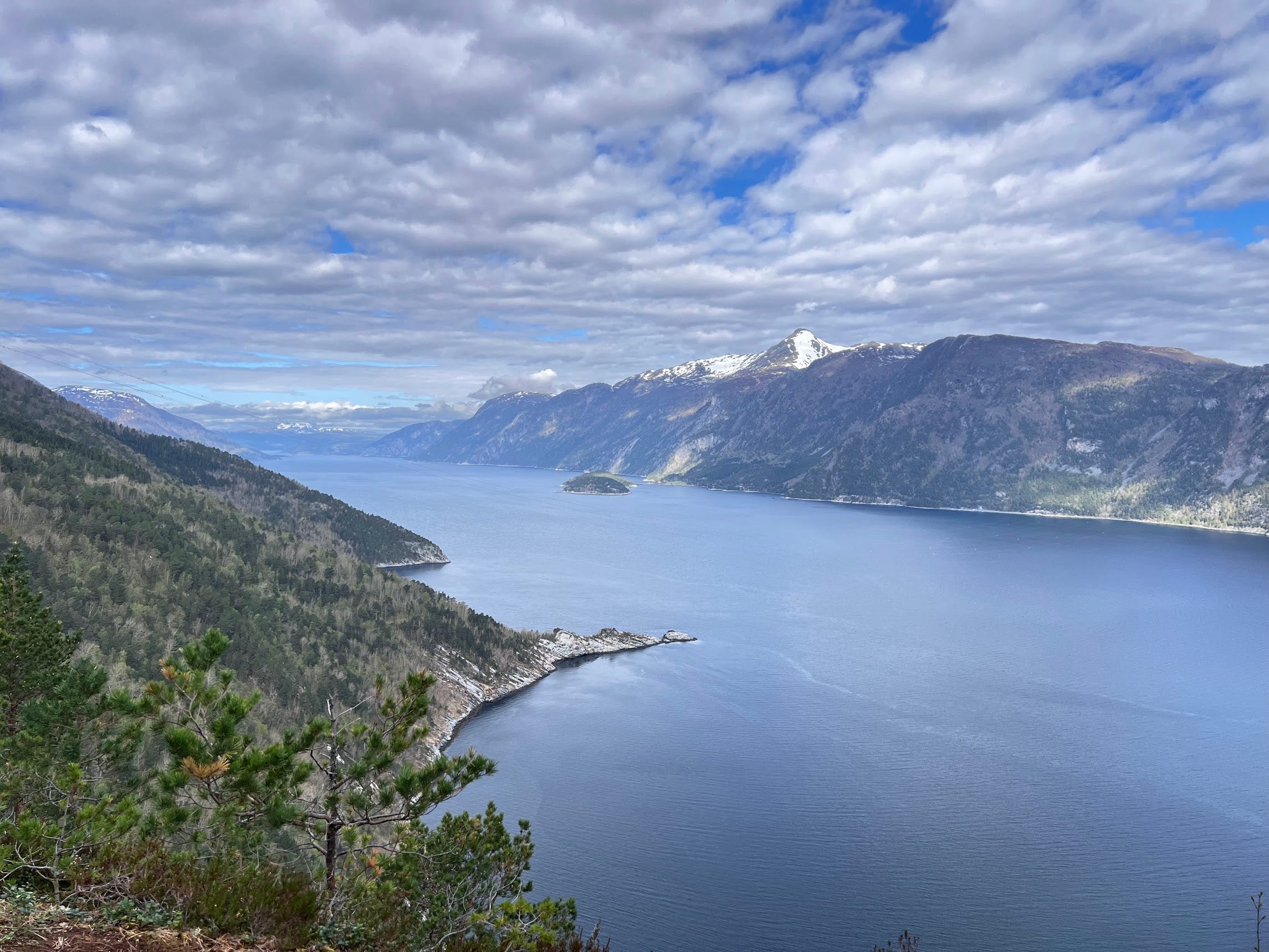
Glaciers are formed when glacial ice accumulates over a large area of land, ideally in areas with very high snowfall in winter and low summer temperatures to prevent the ice from completely melting away (Himalayas, Patagonia, Alaska to name a few). And yes, glaciers are formed in high altitudes like mountains and slowly move downhill with time. As they slowly slide down on their way to the sea, they carve or erode parts of the mountains (like chiseling wood) to create beautiful fjords like those in Norway and New Zealand.
Ice sheets are large masses of glacial ice sitting on continental scale lands that span more than 50,000 square kilometers! We only have two ice sheets on Earth at the moment sitting or sliding atop Greenland and Antarctica. Fresh snow on these ice sheets takes a tiny part of today’s atmosphere and locks it into ice over the coming decades. These polar ice sheets are usually several kilometers deep. As we go deeper, we encounter ice that is older in age, and within that ice, photographs or chemical signatures of atmosphere from those times.
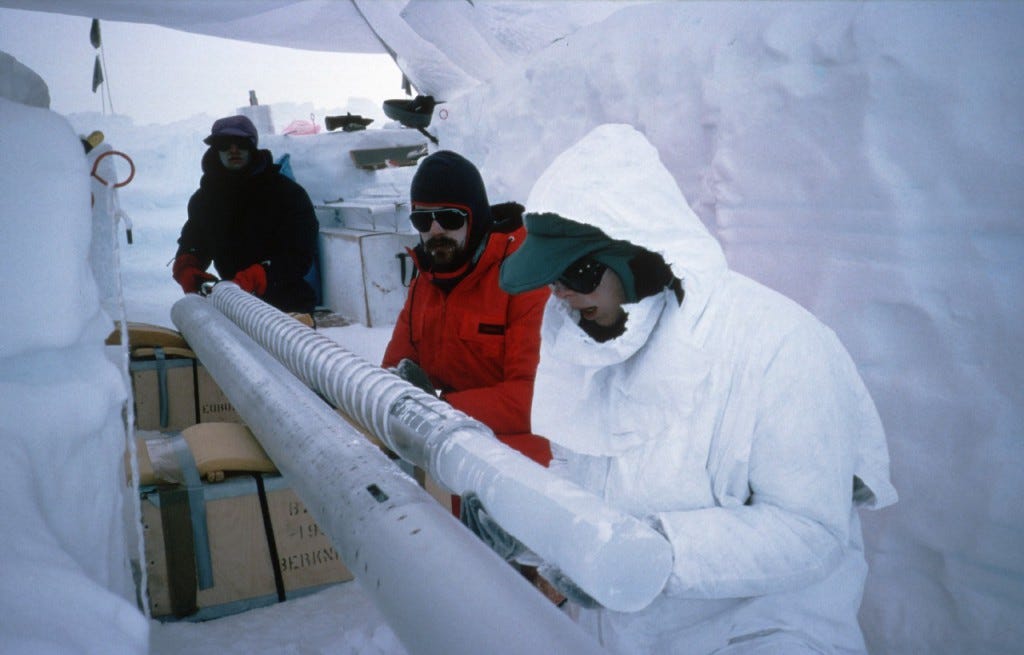
As these regions were very cold and hosting ice sheets from several hundreds of thousands or even millions of years, the air trapped inside the ice holds information about how our atmosphere was like throughout those years. Scientists went to expeditions in Antarctica to drill deep into this ice to study the chemical composition of the ancient atmosphere. Why drilling in Antarctica, and why is this important?
As seen in previous AlterEarth posts, Earth’s atmosphere was constantly changing its composition due to biological, physical and chemical processes occurring on Earth. In the very recent history of the Earth, polar regions like Antarctica were relatively stable, with temperatures continuously cold enough to host large ice sheets and minimal tectonic activity to disrupt them. Due to this, we have a near-continuous record of the atmosphere trapped in these ice sheets. This means we have very frequent pictures of the ancient atmosphere (with annual resolution near the surface, stretching to spanning decades as we go deeper), or should we say photo albums :)
Air bubbles trapped in ice from a 3.2 km hole drilled at a location in Antarctica gave us a very clear picture of how the atmosphere on Earth varied over a span of 800,000 years (resolution of decades is very good in this time scale)! Cross referencing this historical atmospheric data with fossil data and other geological markers from similar time periods in different parts of the Earth helps scientists better understand how and why the Earth evolved the way it did. Cracking this problem can shed some light on how the Earth might change in the future based on what is happening in the present.
How was today’s post?
If you liked it, please hit the Like button at the bottom and share it with a friend. Hit the ‘send message’ button if you want to share feedback. Also, please Subscribe to AlterEarth if you haven’t already. Have a great day!
Here are the references that I used for figures and guidance while writing this piece.
References:
https://dec.ny.gov/environmental-protection/acid-rain
https://www.epfl.ch/labs/lapi/wp-content/uploads/2020/03/Clouds.pdf
https://nsidc.org/learn/parts-cryosphere/glaciers
https://www.antarcticglaciers.org/glacier-processes/from-snow-to-glacier-ice/
https://www.antarcticglaciers.org/glacial-geology/glacial-landforms/glacial-erosional-landforms/fjords/
https://www.bas.ac.uk/news/how-antarctic-ice-cores-give-us-clues-about-earths-future-climate/
https://www.antarcticglaciers.org/antarctica-2/why-study-antarctic-glaciers/
Whitehouse PL, Gomez N, King MA, Wiens DA. Solid Earth change and the evolution of the Antarctic Ice Sheet. Nat Commun. 2019 Jan 30;10(1):503. doi: 10.1038/s41467-018-08068-y. https://pmc.ncbi.nlm.nih.gov/articles/PMC6353952/.
Lambert, F., Delmonte, B., Petit, J. et al. Dust-climate couplings over the past 800,000 years from the EPICA Dome C ice core. Nature 452, 616–619 (2008). https://doi.org/10.1038/nature06763.