

The rain or sunshine outside your window may have been set in motion months ago by winds high above and by distant ocean patterns hidden from view. We like to think the sky decides our weather, but many of the most important influences arrive quietly from far away.
Rivers You Cannot See
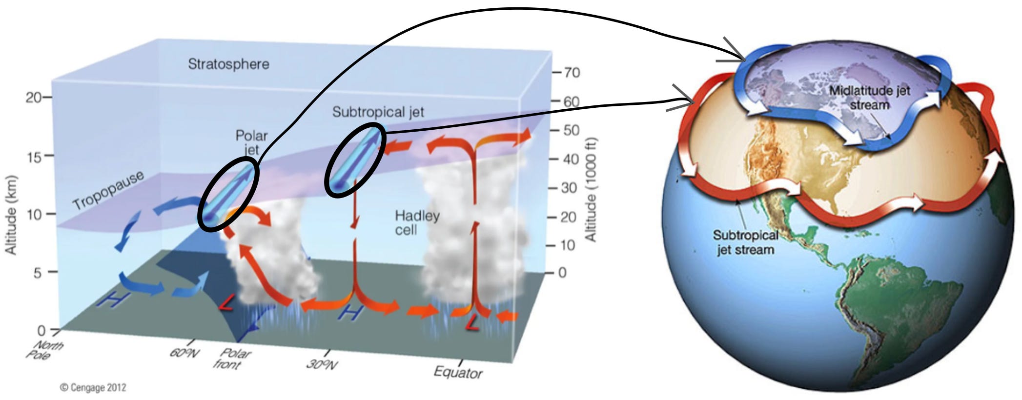
The tropical regions of the Earth soak up far more sunlight than the poles, so without something to move that heat around, the equator would roast while the poles froze solid. The climate system solves this with a planet-wide heat transfer network. About ten to twelve kilometers above us, narrow bands of wind called jet streams race from west to east at roughly 180 kilometers per hour, hauling warmth and storms.
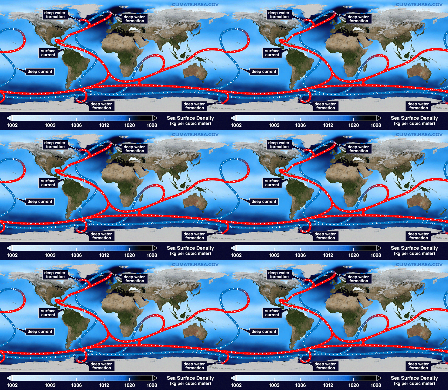
Far below our feet, the ocean carries heat slowly around the planet. This large-scale thermohaline circulation moves warm shallow water towards higher latitudes and returns cold, dense water to the deep ocean. Because seawater stores far more heat than air, the ocean is a major regulator of climate. This circulation is enormous and slow, and it helps keep western Europe milder than many regions in North America at similar latitudes. For example, winters in New York, Chicago and Winnipeg are far harsher than in Naples, Rome and Paris, even though each pair sits at similar latitudes.
The ocean is only part of the reason, though. Much of Europe’s warmth comes from the prevailing westerly winds, which carry over the continent the heat that the Atlantic soaked up during summer, and from the Rocky Mountains, which bend the high-altitude jet stream into a wave that drags cold air south over eastern North America while steering milder air north over Europe. The ocean conveyor adds a real but smaller share, and it matters most at the highest latitudes, where the warm North Atlantic Current keeps Norwegian ports like Tromsø ice-free while the same latitude in Canada lies locked in Arctic ice.
The Pacific’s heat circulation system- What even are El Niño and La Niña?
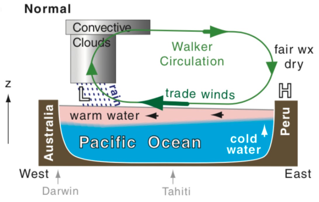
The Earth’s meticulous heat redistribution system could not be clearer than in the tropical Pacific. Persistent trade winds push warm surface water westward from South America, piling it up near Indonesia and deepening the warm upper ocean there, while cold water upwells (cold nutrient rich water rising up to replace warm surface water) off Peru. This nutrient rich water along Peru’s coastline makes it one of the planet's greatest fisheries (nearly 15% of world’s fish comes from this region). This creates a real east-west tilt in sea level and ocean temperature. Above it, the Walker atmospheric circulation completes the loop as warm air rises over the western Pacific, sinks over the cooler eastern Pacific, and helps sustain the trade winds.
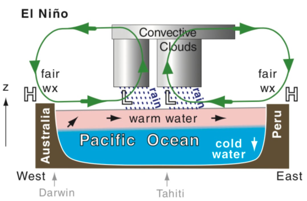
Now, just like we cannot keep working long hours everyday and need weekends to relax or chill, these trade winds might also decide to take a break and maybe not blow as strongly and relax. When this happens, it has implications not only on the local areas where this happens, but on a global scale. As the trade winds that push warm ocean water towards West Pacific weaken or stop, warm near-surface ocean water in East Pacific remains higher than usual. This prevents the deep cold nutrient rich water from rising to the surface and negatively impacts fishing. The South American people called this phenomenon El Niño, which translates to ‘the little boy’ in Spanish and it usually occurs around December.
Just as how we get tired and need a break from work, there are some days where we are extremely motivated and work to the best of our ability, these trade winds also do the same once in a while. When they are stronger than usual, they push the warm near surface waters more strongly towards the West Pacific and this allows more of the deep colder waters to upwell in a wider region of the East Pacific. This deviation from the normal where trade winds are much stronger is called La Niña, which translates to ‘the little girl’ in Spanish and it makes the Eastern Pacific cooler than usual.
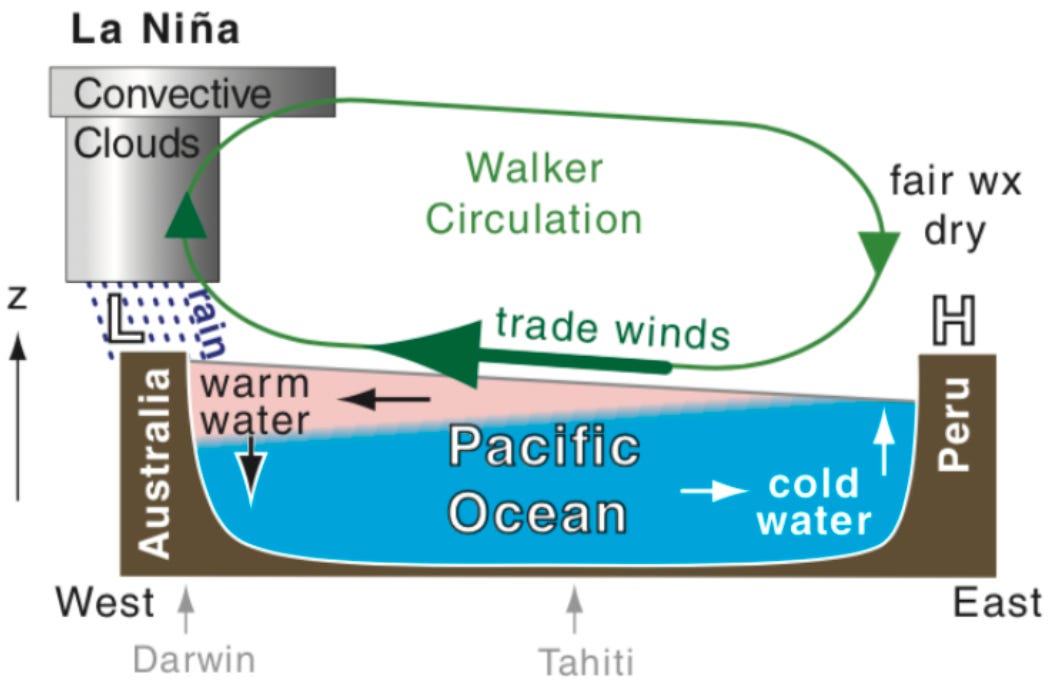
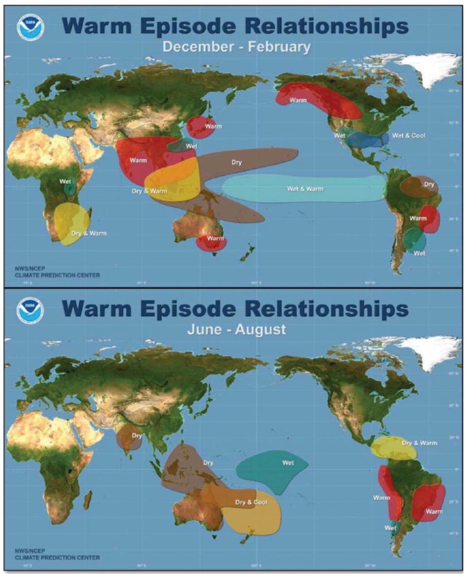
These three states of the tropical Pacific: neutral, El Niño and La Niña, together make up the El Niño-Southern Oscillation, or ENSO. The 'southern' is not the south Pacific. It is the Southern Oscillation, a seesaw in air pressure between the eastern and western Pacific that swings in step with the ocean. So how does a change in one ocean reach the whole world? Picture a restaurant whose entire rhythm is built around one signature dish. The day its key ingredient vanishes from every market, the kitchen falls out of step, the other plates come out late, and diners who travelled across town for that one dish leave disappointed. The tropical Pacific is that signature dish for the planet's weather. When ENSO changes it during an El Niño, the warm rains that usually sit over Indonesia slide thousands of kilometers east, the winds and jet streams reorganize, and far-off regions get floods or droughts they never ordered.
During an El Niño disruption, regions like India tend to get warmer winters and a weaker monsoon, which hits hard in a country where so many livelihoods depend on the rains. Across Southeast Asia and Australia, the same disruption brings drought and fierce wildfire seasons, scorching the rice paddies of Indonesia and drying out the farmland and reservoirs of eastern Australia. In southern Africa, countries like Zimbabwe and Malawi can watch their rains fail at the worst possible moment, withering the maize harvests that millions of people depend on to eat. And along the coast of Peru, the warming water smothers the cold upwelling that feeds the anchovy, collapsing one of the world's largest fisheries and the livelihoods built on it, even as unusually heavy rain floods the normally dry coastal towns.
What is the Super El Niño? Is it heading our way this year?
A super El Niño is the kind where the central Pacific warms to more than about 2ºC above its normal. The heat the ocean had been storing pours back into the air, and for a year or so the whole planet runs a higher fever. It is no coincidence that the last big El Niño helped make 2024 the hottest year ever measured, and the first to edge past 1.5ºC of warming. A strong event taking hold late in 2026 could hand that grim title to 2027, and with it the familiar trail of failed harvests, runaway wildfires, and floods arriving in places already stretched thin.
Simply put, a super El Niño does not make new heat. It hands back heat the ocean was already hiding, onto a world fast running out of room to absorb it.
There is honest uncertainty in the timing, and it deserves respect. NOAA still puts the odds of a truly extreme event at only about 37 %, and spring forecasts have a habit of shifting by late summer. But the current running underneath that uncertainty is not in doubt. A warming world keeps loading these invisible rivers with more heat to carry, and the deep ocean currents that carry it are themselves slowing and growing unsteady under our influence. You can see the strain already. India is already sweltering in the mid-to-high 40s Celsius, and El Niño has not even taken hold yet. Now picture the back half of a year in which the disruption truly arrives, with droughts, wildfires, and floods sharpened beyond anything we have watched before.
El Niño is one of Earth’s oldest natural rhythms, far older than us, and not a switch we flipped. What we have changed is the stage it performs on. The feverish baseline, the record heat, the extra venom in every flood and drought, that part carries our fingerprints. In a real sense these wild swings are the planet answering back to how we have treated her.
How was today’s post?
If you liked it, please hit the Like button below and share it with a friend. Hit the message button if you want to share feedback, and please Subscribe to AlterEarth if you haven’t already. Have a great day!
References
McPhaden, M. J., Zebiak, S. E., & Glantz, M. H. (2006). ENSO as an Integrating Concept in Earth Science. Science, 314(5806), 1740–1745. https://doi.org/10.1126/science.1132588
Jet Stream. https://everestweather.com/mt-everest-weather/jet-stream/
Cai, W., Borlace, S., Lengaigne, M., et al. (2014). Increasing frequency of extreme El Niño events due to greenhouse warming. Nature Climate Change, 4, 111–116. https://doi.org/10.1038/nclimate2100
Thirumalai, K., DiNezio, P. N., Partin, J. W., et al. (2024). Future increase in extreme El Niño supported by past glacial changes. Nature, 634, 374–380. https://doi.org/10.1038/s41586-024-07984-y
Caesar, L., Rahmstorf, S., Robinson, A., Feulner, G., & Saba, V. (2018). Observed fingerprint of a weakening Atlantic Ocean overturning circulation. Nature, 556, 191–196. https://doi.org/10.1038/s41586-018-0006-5
Witze, A. (2026). Are we really headed for a ‘super’ El Niño? What the science says. Nature (News Explainer). https://doi.org/10.1038/d41586-026-01538-0
NOAA Climate Prediction Center, ENSO Diagnostic Discussion (latest advisory). https://www.cpc.ncep.noaa.gov/products/analysis_monitoring/enso_advisory/ensodisc.shtml
NOAA Climate.gov, The Walker Circulation, ENSO’s atmospheric buddy. https://www.climate.gov/news-features/blogs/enso/walker-circulation-ensos-atmospheric-buddy
NOAA National Ocean Service, The Global Conveyor Belt. https://oceanservice.noaa.gov/education/tutorial_currents/05conveyor2.html
NWS JetStream (NOAA), The Jet Stream. https://www.noaa.gov/jetstream/global/jet-stream
World Meteorological Organization, 2024 confirmed as warmest year on record at about 1.55 degrees C above pre-industrial level. https://wmo.int/news/media-centre/wmo-confirms-2024-warmest-year-record-about-155degc-above-pre-industrial-level
The Humboldt Current: A sea full of life to feed the planet. https://www.nature.org/en-us/about-us/where-we-work/latin-america/stories-in-latin-america/humboldt-current-fishing-biodiversity/
The Walker Cell and ENSO. https://www.eoas.ubc.ca/courses/atsc113/sailing/met_concepts/09-met-winds/9c-walker-cell-enso/
Global impacts of El Niño and La Niña. https://www.climate.gov/news-features/featured-images/global-impacts-el-niño-and-la-niña
Urgent call to action to address historic El Niño drought in Southern Africa. https://www.wfp.org/news/urgent-call-action-address-historic-el-nino-drought-southern-africa
Shultz, J. M., Shepherd, J. M., Bagrodia, R., & Espinel, Z. (2014). Tropical cyclones in a year of rising global temperatures and a strengthening El Niño. Disaster Health, 2(3–4), 151–162. https://doi.org/10.1080/21665044.2014.1111722
Slowdown of the Motion of the Ocean. https://science.nasa.gov/earth/earth-atmosphere/slowdown-of-the-motion-of-the-ocean/
India’s heatwave crisis: How IMD classifies extreme heat and why 2026 is so hot. https://www.businesstoday.in/india/story/indias-heatwave-crisis-how-imd-classifies-extreme-heat-and-why-2026-is-so-hot-532059-2026-05-18
Thanks for this wonderful article Sri. This article is a fountain of information on El Niño. 🙏