
E4: Earth's crust is a bunch of broken pieces constantly moving around

Did you know that Iceland is the one of the youngest landmasses (not as a country, but literally the land) on Earth and is just 16 - 18 million years old? On the other hand, some old rocks in its neighbor Greenland are nearly 4 billion years old.
The crust that we stand on and the oceans rest upon is not a single solid block, but it is a bunch of broken pieces that are always moving around. This movement is neither the rotation of the Earth along its axis nor the revolution around the Sun, but rather, the surface we are on is literally moving all the time. This process, technically known as ‘plate tectonics’ is constantly creating and destroying parts of the crust as you are reading this post, but in a very slow pace that is similar to how fast our fingernails grow (around 10 mm/year). But, when and how did all this start?
Nearly 4 billion years ago, when the Earth started to cool down, its hot surface was getting solidified into a very thin layer like a thin layer of skin forming on hot milk as it cools down.

The early mantle was very active back then. So, as the crust started to solidify, the strong convection currents in the mantle started breaking it up nearly everywhere and adding new material to the surface. The mantle sent its material out on to the crust through millions or hundreds of millions of years of continuous volcanic explosions and magmatic outbursts from the cracks in the crust. Along with the mantle material expelled by volcanoes that solidifies to form the crust, immense amounts of gases and ash was also released that formed the first atmosphere in a process called volcanic outgassing.
Over hundreds of millions of years, thick layers of new land got solidified and all the expelled gases created the first atmosphere. The main contents of our early atmosphere were:
Water vapor (H₂O)
Carbon dioxide (CO₂)
Nitrogen (N₂)
Other gases like methane (CH₄), ammonia (NH₃), and sulfur dioxide (SO₂).
When the Earth cooled down a bit, the water vapor in the atmosphere started to precipitate, it was raining heavily for centuries or millions of years all over the Earth that formed the world’s oceans, along with some contribution from comets and asteroids carrying water. This further cooled down our accumulated ‘thick’ crust and formed oceans. This thick crust was not one continuous piece of solid material, it was made of many large broken pieces that were moving slowly, all thanks to the convection currents of magma in the mantle.
The earliest stable plates or large rock masses are called cratons and are found in:
Parts of Canada and Greenland (nearly 4 billion years old)
Large rocks in South Africa, Asia and Australia (nearly 3 billion years old or more)
Jigsaw puzzle on Earth
Did you ever take a close look at the world map and think that South America could fit right into the western part of Africa although they are very far away? They were indeed attached together millions of years ago!
There are seven large ‘plates’ that make up nearly 94% of the surface. The other plates are much smaller and cover the rest of the surface. Continental plates are the ones we are standing on and have depths ranging from 40 - 70 km from the surface until the upper mantle. Oceanic plates are the blocks of rocks upon which the oceans rest and they range from 5 - 10 km in thickness. The figure beneath shows the current layout of all the ‘tectonic plates’ on Earth.

There are three types of tectonic plate boundaries-
Plates that move apart from each other and the mantle material that comes to the surface forms new crust are called divergent (or constructive) plate boundaries. In these types of boundaries, the crust becomes very thin as both plates are pushed apart to let the magma out.
In the figure above, divergent boundaries are indicated with the small red arrows are pointing away from each other. The middle of the Atlantic Ocean has an active divergent plate boundary called the Mid-Atlantic ridge that created a big underwater mountain range over millions of years. Iceland is just one part of it that popped out of the ocean starting from nearly 18 million years ago. In several million years from now, the landmass of Iceland would be much bigger as it is constantly growing!

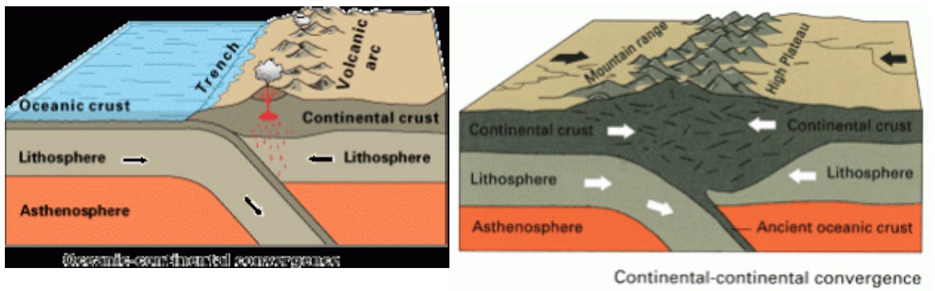
In the case where plates that move towards each other, the denser one out of them (usually the oceanic plate) goes below the other (continental or other oceanic plate) into the mantle and gets destroyed in the upper mantle. These kind of boundaries are known as convergent (or destructive) plate boundaries. The plate that goes into the mantle gets melted by the heat in the mantle and this melted material rises back the surface to create volcanoes on continental plates (Cascade mountains, West Andes mountains) or volcanic islands on other oceanic plates (Island chains in the Pacific). In the world map above, convergent boundaries are indicated by red arrows pointing towards each other.
However, when two continental plates collide into one another, neither of them are dense enough to go beneath the other, so the push into each other and rise up to form fold mountain ranges like the Himalayas.
The other kind of plates where they rub against each other without creating or destroying crust are called transform plate boundaries. The most common example is the San Andreas fault in California.

Evolution of the land on Earth over millions of years
We now know how the plates move and interact with each other, and that all of this started happening from nearly 3.5 billion years ago. In the early 1900s, Alfred Wegener proposed a theory that all continents were once joined together in a supercontinent called Pangaea. It received wide backlash from the scientific community at that time due to lack of evidence or physical explanation. But slowly, they started finding fossils of the same species of animals and plants on India and Australia, South America and Africa and this was very strong proof that they were once together. The reason these fossils were irrefutable proof of plate movement is because the animal and plant species could not travel large distances in the ocean from one continent to the other as they are in the current structure.
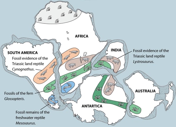
Based on this fossil evidence and other physical mechanisms that were discovered proving that continents actually move, scientists reconstructed how the Earth looked like millions or even billions of years ago. As the current continents were once together as one landmass, they were referred to as Supercontinents. The figure below shows how the Supercontinents on Earth evolved with time. After Pangea, the supercontinent started to split apart and eventually led to the current continent structure.

Throughout billions of years, many plates got created and some of them also got completely destroyed by melting into the mantle. There are also some cratons that survived all these hard times and are still intact like in Canada, Greenland, Australia, South Africa and many parts of Asia (from 3 - 4 billion years ago).
Today’s plates move at an average speed of 1 - 10 cm/year with the continental plates being slow (1 - 6 cm/year) and oceanic plates like Pacific plate move around 10 cm/year. So, around 50 - 100 million years from now, the landscape of the Earth will be completely different with new oceans and continents and maybe some parts of the known ones being destroyed.
How was today’s post?
If you liked it, please hit the Like button at the bottom and share it with a friend. Hit the ‘send message’ button if you want to share feedback. Also, please Subscribe to AlterEarth if you haven’t already. Have a great day!
Here are the references that I used for figures and guidance while writing this piece.
References:
https://guidetoiceland.is/nature-info/geology-of-iceland
https://www.britannica.com/science/geologic-history-of-Earth/Development-of-the-atmosphere-and-oceans
https://earthobservatory.sg/earth-science-education/earth-science-faqs/geology-and-tectonics/where-do-we-find-the-oldest-continental-rocks-and-the-oldest-seafloor
https://www.gsi.ie/en-ie/education/our-planet-earth/Pages/Plate-Tectonics.aspx
https://commons.wikimedia.org/wiki/Category:Plate_tectonics
https://www.geologyin.com/2024/03/divergent-boundary-definition-features.html
https://geo.libretexts.org/Bookshelves/Geology/Book%3A_An_Introduction_to_Geology_(Johnson_Affolter_Inkenbrandt_and_Mosher)/02%3A_Plate_Tectonics/2.03%3A_Convergent_Boundaries
https://study.com/academy/lesson/transform-boundary-definition-facts-examples.html
https://oceaniq.co.uk/news/the-seafloor-is-constantly-changing-what-can-the-history-of-plate-tectonics-teach-us/
https://www.nature.com/articles/s43017-021-00160-0
https://www.britannica.com/science/plate-tectonics/Plate-tectonics-and-the-geologic-past
https://www.geologyin.com/2025/03/how-fast-do-tectonic-plates-move.html